
Irhazer Fm
Type Locality and Naming
Joulia (1955) emend. Bigotte & Obelianne (1968). Group/Subgroup: Irhazer Gr , Dabla Sub-group. [NOTE: this Formation should be renamed since it does not meet the stratigraphic guidelines of the International Commission on Stratigraphy (Web-09).]
References: Greigert et al., 1954; Faure et al., 1956; Greigert et al. 1958; Faure, 1966; de Lapparent et al., 1966; Taquet, 1967; Valsardieu, 1971; Fabre et al., 1983; Kogbe, 1991; Moody, 1997; Rauhut & López-Arbarello, 2009; Remes et al., 2009; Mudroch et al., 2011.
Synonym: "Argiles de l’Irhazer"; *Argiles de l’Irazer; Ighazer (both misspelling); Irhazer Shales. Moody (1997) mentions the Azenak and Kouichi Members of the Irhazer Fm. However, no details were given, and no other references to these names were found. They are believed to be equivalent to the “In Gall” and “Gelili” Members, respectively. Synonym for Gelili Mbr = Grès conglomératique de Gelili"
Lithology and Thickness
The Irhazer Fm is made up of shales, silty shales, conglomerates with shaly pebbles, fine sandstones, limy-sandstones, copper and uranium sandstones deposited in flat channels. The base of the Irhazer formation can display a conglomerate (Gelili Mbr - not always present). The upper limit is unclear (passage zone of the In Gall Mbr). Above the Irhazer shales: to the west and south-west of the Aïr, one notes from bottom to top, brown to illite shales, variegated clays, carbonates, polygenic conglomerates with calcareous cement, silts and fine fossiliferous sandstones (fish, dinosaurs, plants), then an alternation of dolomitic limestones, clays and siltstones. To the south appear sandstones with oblique stratification, calcareous cement and arkose channels with large feldspars and shaly pebbles.
The In Gall Mbr (0 to 30 m) corresponds to homogeneous sandstones, poor in feldspar, rich in mica, pyrite, carbonaceous debris, well stratified or in lenses in argillites. This Member does not exist everywhere (Fabre et al., 1983). This upper part of the Irhazer Fm was deposited in a meandering, shallow river system dominated by overbank silt deposition. Shallow lakes are rich in ostracods, with soils developed in waterlogged areas due to temporary pulses. The shallow lakes were widespread, their waters replenished by overbank flooding from nearby river channels. As indicated by the dimensions of the preserved channel systems, these channels were less than 2 m deep and 50 m wide. Shallow, poorly developed cross-beds characterize them and lag deposits with abundant transported, slightly abraded vertebrate material. The indication is relatively sluggish water movement (Moody, 1997). Thickness is 200-250 m to the west and disappears to the east before 9°E (Faure, 1966). See Dabla Subgroup in Irhazer Gr
Relationships and Distribution
Lower contact
Underlain by the Assaouas Fm (when present) or the Tchirezrine 2 Mbr of the Tchirezrine Fm.
Upper contact
Unconformably overlain by the Tiouraren Fm
Regional extent
GeoJSON
Fossils
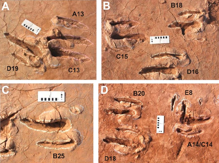
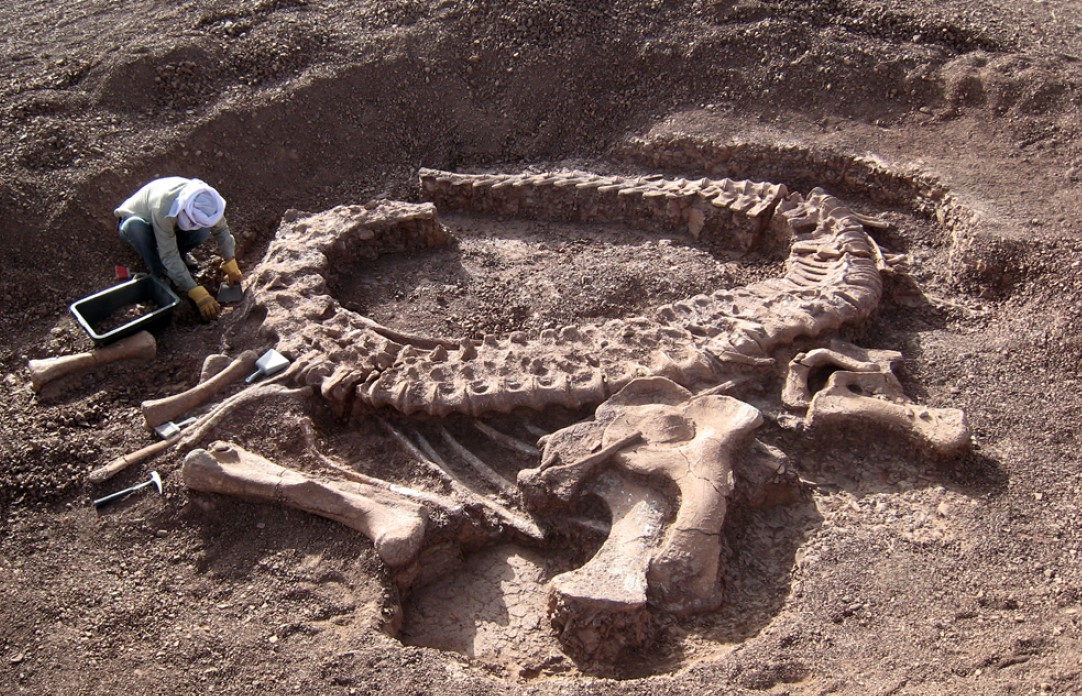
Freshwater invertebrates (Estheria, Unio), lamellibranchs (Cuneopsis, Unio, Cyrena, MONGIN, 1963), fish (Ceratodus) (Greigert et al., 1958), Sauropod (Spinophorosaurus nigerensis) (Fig. 7-79), theropods and crocodiles. Salamander tracks and one hundred twenty (120) exceptionally well-preserved didactyl (pentadactyles et tridactyles) tracks of an unknown bipedal theropod and six tracks of a medium-sized quadrupedal sauropod were found and described by de Lapparent et al. (1966) and Mudroch et al. (2011) (Fig. 2) from both the Assaouas Fm and the Irhazer Fm.
[Figure 1. Tracks from different parts of the tracksite area. Scale bar equals 10 cm. A) Examples of superimposition and disturbance of tracks. B & C) Undisturbed tracks. D) Track A14/C14 to the right results from a superimposition of two nearly identical footprints and is disturbed by track E8 of the crossing trackway; tracks B20 and D18 on the left are undisturbed (Source: Mudroch et al., 2011).]
[Figure 2. Spinophorosaurus nigerensis in situ during excavation in the region of Aderbissinat, in the “Falaise de Tiguidit” (Source: Remes et al., 2009).]
Age
Depositional setting
Continental fluvio-lacustrine
Additional Information